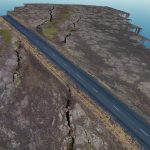
Faults and fractures in the Northern Volanic Zone, Iceland
Home page
We want to believe
 We believe that nowadays the use of new technologies is crucial for improving teaching and popularization of science in general and at all levels, much more importantly for Earth Sciences.
The novelty we propose is devoted to the creation of a digital platform for the visualization and navigation of terrestrial and seafloor environment, that allow us to disseminate knowledge in GeoScience as never done before:
The Argo3D platform.
Data in the form of imagery and topographic surface models taken from airborne and submarine remotely operated drones will be used to create virtual reality models that can be used interactively within an innovative 3D Lab. Thanks to VR environment, students and teachers will be able to collaborate in a virtually-reconstructed ambient that represents real "geological" places on Earth.
 Funding is from Ministero dell'Istruzione dell'Università e della Ricerca (MIUR), project ACPR15T4_00098: Agreement between the University of Milan-Bicocca and the Cometa Consortium for testing cutting-edge interactive tecnologies to improve teaching and outreach activities in Earth Sciences.


